
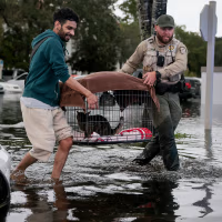
Storms that drenched South Florida with record rainfall this week moved northward on Thursday, flooding rivers and prompting rescues of both people and horses on the Space Coast.
At the same time, rain continued to batter California’s coast, flooding streets, submerging vehicles and causing hundreds of flight delays.
The heavy precipitation comes during Florida’s typical dry season, which normally runs from October through May, but this year has been anything but dry.
“Never seen anything like this in Florida,” said Jazmin Foster, who has lived in her Melbourne home for eight years.
Preliminary data from the National Weather Service show that the Fort Lauderdale area has received almost 17 inches of rain in a 48‑hour span. The service also reported that Fort Lauderdale, Melbourne and West Palm Beach have already experienced their wettest November on record.
Meteorologists say the storms have been driven by a persistent high‑pressure ridge over Virginia combined with a low‑pressure system and a stationary front in the Gulf of Mexico, creating a steady onshore flow across the peninsula. Heavy rain and flash flooding are expected to continue through Friday and could shift northward toward the Carolinas and the Mid‑Atlantic over the weekend, the agency added.
In Brevard County, the storms hit hard on Thursday. Volunteers waded through knee‑deep water to rescue dozens of horses and other animals from the Blue Lake Equestrian Center, an animal hospice and boarding facility in Cocoa, moving them to a dry pasture. Sheriff Wayne Ivey said first responders carried out nearly 100 high‑water rescues across the county, and the number was still rising. Palm Bay ordered mandatory evacuations for part of a mobile‑home community and opened shelters for displaced residents.
Foster’s home was flooded on Thursday, just two weeks after a previous bout of flooding. She said an insurance claim for the earlier flood was denied and asked on social media, “Where is FEMA? Multiple people here in Brevard need help! I know other people are worse than we are!”
The Division of Emergency Management deployed almost 200 Florida National Guard members with 50 high‑water vehicles, while the Florida Fish and Wildlife Conservation Commission contributed about 235 officers.
The St. Johns River near Cocoa surged above the record flood level set in 1953 and was projected to remain at least two feet above flood stage through early next week, according to the weather service.
In Cocoa, Cyndy Paulin watched a fish swim down her flooded street on Thursday while her five‑year‑old granddaughter played in the water. The child tried to ride a small body board, which sank immediately, leaving her drenched. “She had a blast,” Paulin said.
Meteorologists link the storms to an El Niño event, a natural warming of the equatorial Pacific that disrupts weather patterns worldwide. Forecasts indicate El Niño conditions will persist into the spring, suggesting that the wet, extreme weather affecting Florida and California could continue throughout the winter. “That’s what the forecast models are saying,” said Jeff Masters, a meteorologist with Yale Climate Connections. “Winter hasn’t even arrived—we’re still in November—and things are likely to become even more active. With record‑warm ocean temperatures off both California and Florida, we can expect very heavy downpours.”
In July, United Nations officials warned that El Niño would exacerbate the global climate crisis driven by fossil‑fuel combustion.
Long‑time Pompano Beach resident Ken Evans noted that rain and flooding have intensified, especially over the past five years. He recounted being caught in his SUV on Interstate 95 north of Miami on Tuesday night during a heavy downpour that included hail, which left many roads underwater. “This is absolutely a whole new cycle that’s going on, and a cycle that we should be very concerned about,” he said.
In Southern California, a Los Angeles area recorded more than three inches of rain in a 12‑hour period ending Thursday, according to the weather service, prompting some drivers to abandon stalled cars in floodwaters. More than 200 flights at Los Angeles International Airport were delayed that day—about 12 % of total traffic—though only a few were cancelled, per Flightradar24.
Further north, rock and mudslides in Big Sur forced a closure of over 40 miles of Highway 1 along the Pacific coast.
In West Oakland, Adriana Uchishiba woke on Wednesday to find her bed floating in a flooded bedroom. A heater remained plugged in, and she could feel electricity in the water. A maintenance worker brought dehumidifiers and a water‑suction pump, and Uchishiba hopes the quick response will prevent mold. Friends have been helping by washing her clothes and providing supplies, but she and her roommate still need new beds, blankets and books. “If it wasn’t for my friends coming out and showing up … this place would still be underwater,” she said.
The National Hurricane Center in Miami warned that a non‑tropical low expected to form on Friday could develop into a subtropical or tropical storm along the southeastern U.S. coast. The Southeast and Mid‑Atlantic coasts should brace for strong winds, hazardous surf and coastal flooding into early next week.
In Southern California, the weather service forecast extremely high tides exceeding eight feet (2.4 meters) to continue through next week.